Google Maps 和 Google Earth 开始显示公共交通信息

Written on June 6, 2007 by KennyP

Google Maps 和 Google Earth 开始显示公共交通信息

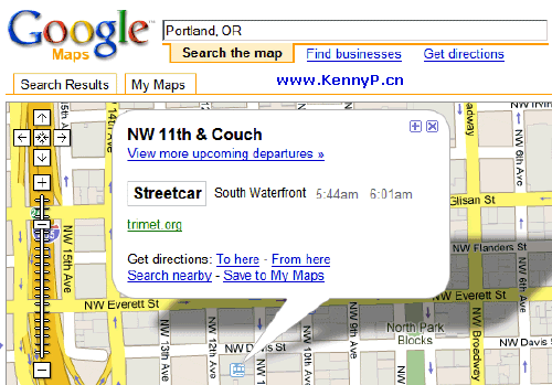
Google 终于开始在 Google Maps 和 Google Earth 显示公共交通信息地铁站、轻快铁站和巴士站,更多的截图请继续往下看。

Google Maps 和 Google Earth 开始显示公共交通信息

Google Maps 和 Google Earth 开始显示公共交通信息

与其他的 Google Maps 服务一样,目前这个服务只有在美国和欧洲一些主要城市提供,其他的地方像马来西亚和中国就只要漫长的等待了。

不过这个功能真的非常便利,真希望可以使用。

Popularity: 2% [?]

KennyP

Tags

, , ,

Related Posts

  • Google Maps 不但可以看 竟然还可以听
  • Google Maps 更方便的路线设定
  • Microsoft Live Maps/Virtual Earth 更新了 26 Terabytes 的数据
  • 用 Google Maps 竟然可以看到比基尼
  • Google Maps 出现女生走光暴露照片
  • Leave a Reply

    XHTML: You can use these tags: <a href="" title=""> <abbr title=""> <acronym title=""> <b> <blockquote cite=""> <cite> <code> <del datetime=""> <em> <i> <q cite=""> <strike> <strong>