Posts Tagged 'google maps'
Written on
June 30, 2007
by
KennyP

欧美的网民很幸福,在 Google Maps 他们除了可以看到自己城市的高解像度卫星图片,他们还可以使用 Google Maps 的导航功能。
他们只要告诉 Google Maps 自己在什么位置,打算去什么地方, Google Maps 就会在地图上显示出全程的路线,还用文字详细地说明要怎么走。
刚刚 Google Maps 的更新让他们在决定行走的路线时更方便了,他们可以以拖放的方式随意改变在 Google Maps 的路线。如果你不明白我在说什么,没关系,我们直接看看实际操作,这是 Google 官方制作的 YouTube 视频。
Read the rest of this entry »
Popularity: 3% [?]
 Posted in 新闻资讯, 互联网
  No Comments »
Written on
June 27, 2007
by
KennyP
Google 的照片分享网站 Picasa Web 如今可以让你在地图上看照片。除了拥有经纬度的照片,你也可以自己以拖放的方式把照片放到地图上。

不但如此, Google 还将幻灯片和 Google Maps 结合了起来。当你播放幻灯片,地图的位置会随着不同的照片而改变,非常有趣。
Google 最近收购了一间研究相关技术的公司 Panoramio ,她的技术就是让照片和拍摄地点联合起来,我们可以期待更多相关的功能。
我们未来可能可以以地方来搜索照片,比如说我搜索“香港”, Google 就会显示所有在香港拍摄的照片。
相关链接: • Picasa Web • 幻灯片和 Google Maps 的结合 • Panoramio 官方网站
Popularity: 3% [?]
Posted in 新闻资讯, 互联网 No Comments »
Written on
June 13, 2007
by
KennyP
Google Maps 一下子更新了很多高解像度的卫星地图,其中英国大部分地区的地图已经是高解像度。
以下是这次 Google Maps 的地图更新地区:
New high resolution:
Canada: Whistler, BC; Waterloo & Toronto, Ontario; Nanaimo, BC; and Fort Saskatchewan, AB England: Base 50cm coverage of nearly entire country, and Avon Germany: Cities/Regions of Greifswald, Trier, Köln, Stuttgart, Bonn, Oldenburg, Rostock, Saarbrücken, Hamburg, Hannover, and Ritterhude Austria: Villach region France: Cities of Caen, Dijon, Metz, St Etienne, Toulouse and Rouen Spain: Valencia Andorra US: Imperial County (CA); Yellowstone National Park (WY); Galveston/Houston (TX); Peterborough (NH); Cheyenne (WY); Burke, Wake, and Cabarrus Counties (NC); Racine and Kenosha Counties (WI); Washington, DC; St Paul (MN); and the State of Alabama Japan: City/Regions of Kochi, Asahikawa, Koriyama, Miyazaki, Nagano, Utsunomiya, Akita, and Toyama
Read the rest of this entry »
Popularity: 3% [?]
Posted in 新闻资讯, 互联网 No Comments »
Written on
June 11, 2007
by
KennyP
如果你到现在还不知道 Google Maps 的新功能 Streetside View 没关系,因为我这里有很多相关资料,你可以看看我对 Streetside 的介绍和我在纽约逛街的奇遇,有很多人通过 Google Maps 发现了许多来自 Streetside View 的有趣照片。
现在又有人在 Google Maps 发现了有趣的图片,可是因为内容是限制级的,所以很快被 Google 移除了,这就是 Google Maps 限制级内容的截图。
限制级内容被 Google 拿掉了你是不是很失望?我明白了你们的需要,所以帮你找来了被移除前的这张照片,请看。
Read the rest of this entry »
Popularity: 4% [?]
Posted in 新奇有趣, 互联网 No Comments »
Written on
June 6, 2007
by
KennyP
Google 终于开始在 Google Maps 和 Google Earth 显示公共交通信息地铁站、轻快铁站和巴士站,更多的截图请继续往下看。
Read the rest of this entry »
Popularity: 2% [?]
Posted in 新闻资讯, 互联网 No Comments »
Written on
June 3, 2007
by
KennyP
让你 360 度全景看街道的 Google Maps 新功能 Streetside View 你已经试用过了吗?我自己就已经玩了一下还发现了一些有趣的东西,还有人制作了最好的 15 个 Google Streetside View 。
你会不会和我有同样的疑问?到底 Google Maps Streetside 上这些这么清楚的图片或照片是从哪里来的?是谁拍来的呢?不管你有没有问过这样的问题,我直接在这里揭晓,就是下面这个。

Google Maps 的 Streetside 图片就是这辆福士新甲虫 Volkswagen New Beetle 和车顶上的 Street Level View-Mobile 摄影机所拍出来的。这辆车由 Immersive Media 所拥有, Immersive Media 就是把 Streetside 图片卖给 Google 的公司,这辆车可以一面走一面拍下 360 度的全景照片。
Popularity: 3% [?]
Posted in 互联网 No Comments »
Written on
June 2, 2007
by
KennyP
自从前几天 Google Maps 推出了新功能 Streetside View 后,网民们多了一个新的爱好,就是像我这样用 Google Maps 到处逛街,看到了好镜头就马上拍下来放到网上跟大家分享,我也这样做了。
拍得的镜头多了,就有人整理出了最好的 15 个 Google Streetside View ,我们一起来看看。
Read the rest of this entry »
Popularity: 3% [?]
Posted in 新奇有趣, 互联网 No Comments »
Written on
May 31, 2007
by
KennyP
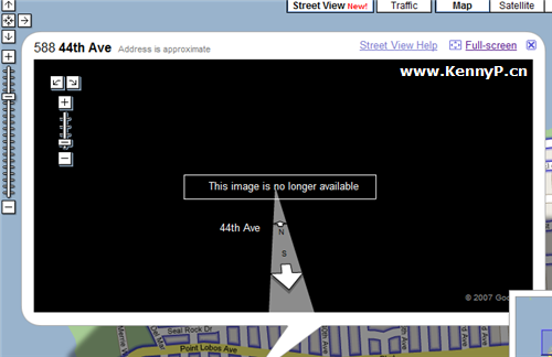
刚才我看在家无所事事,不就到纽约市中心逛逛街,看看会不会发现什么有趣的东西,怎么知道逛了一下,有趣的东西还没有发现,诡异的东西却被我撞到了。
我身在马来西亚可是为什么可以这么轻易就到了纽约市逛街呢?很简单,用 Google Maps 的 Streetside View 连你也可以到世界各地到处逛街,那么我刚才逛街看到了什么东西呢?请继续往下看。
Read the rest of this entry »
Popularity: 4% [?]
Posted in 重要文章, 关于我自己, 新奇有趣, 互联网 No Comments »
Written on
May 31, 2007
by
KennyP
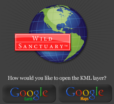
Wild Sanctuary 公司给 Google Earth 和 Google Maps 设计了一层类似插件的东西,称为 KML layer ,让你在相应的地区不但可以看到地图和卫星照片,还可以听到来自当地的声音。目前他们只有来自世界各地收集回来的 30 个声音。
据称, Wild Sanctuary 的 Bernie Krause 花了 40 多年的时间从世界各地收集来超过 3500 个小时的声音录音,他的公司现在打算把这些声音嵌入到 Google Earth 。
你现在可以马上到 Google Maps 听听在肯尼亚草原的雨声,请到 Wild Soundscape Project 。昨天 Google 可以看到街道,今天我们可以听到声音,再过不久我们不再需要监视器和窃听器了, Google 一下可以了!
Popularity: 3% [?]
Posted in 新闻资讯, 互联网 No Comments »
Written on
May 30, 2007
by
KennyP
我刚才在《 Microsoft Live Search Maps 的 3D 立体卫星地图》告诉了大家, Microsoft 的 Microsoft Live Search Maps 如何在技术和功能上领先了 Google 的 Google Maps 。
刚才 Google 反击了,她给 Google Maps 增加了新功能 Streetside View ,让你用新的视角看世界。如果说 Microsoft Live Maps 像是在直升机上看城市, Google Maps 就像是身在其境,你就像在街道上走。
Read the rest of this entry »
Popularity: 4% [?]
Posted in 重要文章, 新闻资讯, 互联网 No Comments »

